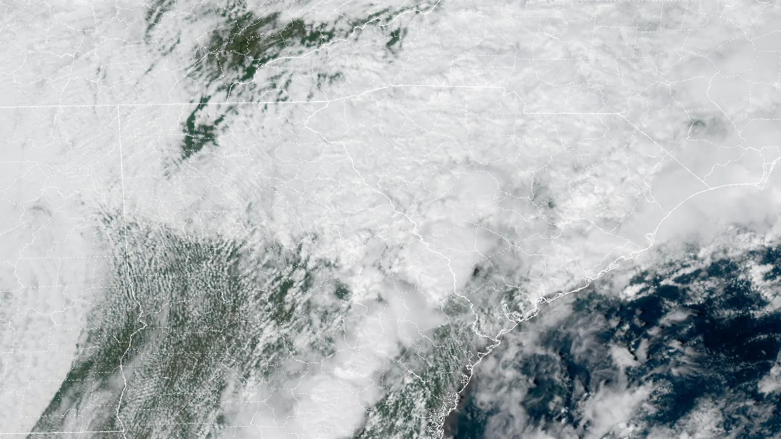
Isaias left 2 to almost 5 inches of rain across Augusta, with 4.84 inches at Fort Gordon. An EF1 tornado hit near Waynesboro. The gauge totals are here.
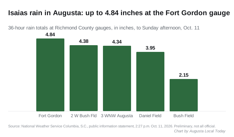
Isaias dropped between 2 and almost 5 inches of rain on Augusta between Friday night and Sunday afternoon. The highest reading in Richmond County was 4.84 inches at the gauge the National Weather Service lists as Fort Gordon.
Updated Oct. 15: the Weather Service’s damage survey rates the Burke County tornado near Waynesboro an EF1, with peak winds of 110 mph. It found no tornadoes in Richmond or Columbia counties.
The figures come from a public information statement the Weather Service office in Columbia, South Carolina, issued at 2:27 p.m. Sunday. It lists 36-hour totals from airport stations, volunteer observers and river gauges. The office says the readings are preliminary and not all of them are official.
How much rain fell in Augusta
The Richmond County totals in the statement:
| Gauge | Rain |
|---|---|
| Fort Gordon | 4.84 inches |
| 2 miles west of Augusta Regional Airport at Bush Field | 4.38 inches |
| 3 miles west-northwest of Augusta | 4.34 inches |
| Daniel Field | 3.95 inches |
| Augusta Regional Airport at Bush Field | 2.15 inches |
The two readings near the airport show how patchy the rain was. A volunteer gauge 2 miles west of Bush Field caught 4.38 inches, while the airport’s own station recorded 2.15.
Neighbors saw similar amounts:
- Evans, about 15 miles northwest: 5.18 inches at a volunteer gauge 3 miles north of town, the highest Georgia reading in the statement
- North Augusta, South Carolina, about 13 miles north: 4.36 inches
- Martinez, about 11 miles northwest: 3.85 inches
- Waynesboro, about 19 miles south: 2.25 inches
The flash flood warning
The Weather Service issued a flash flood warning for Richmond County at 4:36 p.m. Saturday. It said radar showed 2 to 3 inches had already fallen, with 1 to 3 inches more possible. The warning also covered parts of Columbia, Burke, Aiken and Edgefield counties, and stretches of Interstate 20 and Interstate 520.
By 5:33 p.m., the office estimated 3 to 4.5 inches had fallen. The warning expired at 6:30 p.m. once the heavy rain ended. A flood watch for the area ran until 8 a.m. Sunday.
A tornado near Waynesboro
None of the tornado warnings the Columbia office issued Saturday covered Richmond County. The worst damage reported near Augusta was in Burke County.
At 3:36 p.m. Saturday, Burke County emergency management reported a tornado about 6 miles west of Waynesboro, roughly 18 miles south of Augusta. Its report to the Weather Service cited “numerous reports with video and drone footage of several destroyed homes, flipped farm equipment, and considerable tree-powerline damage along highway 80 west of Waynesboro.”
The Weather Service has since surveyed the damage. Its damage survey statement, last updated Tuesday, Oct. 13, rates the Burke County tornado an EF1:
- Peak wind: an estimated 110 mph
- Path: 2.7 miles long and up to 100 yards wide
- Time: 3:30 to 3:44 p.m. Saturday
- Route: from swampland south of Highway 80 near Rocky Creek, northeast across Highway 80 and Abrams Road, then north across Forest Hill Road
- Injuries: none
The survey found roof damage, uprooted trees, a toppled center-pivot irrigation system and several overturned tractor-trailers at a farmstead on Highway 80. The rest of the damage was mainly trees and limbs.
The same statement lists four tornadoes in South Carolina that day and the next: in Aiken County near Wagener, two in Barnwell County, one of them an EF2, and an EF2 in Newberry County. It lists none in Richmond or Columbia counties.
Burke County emergency management also reported a washed-out road near Keysville Boggs Academy Road and Taylor Road at 5:15 p.m. Saturday.
What the city did
Augusta closed two boat ramps on Saturday, the Boathouse Boat Ramp at 101 Riverfront Drive and the Baurley Boat Ramp at 2118 Lock and Dam Road, “until conditions allow reopening.” That is according to the Augusta Emergency Management Agency’s Oct. 9 release.
Augusta Transit, ADA paratransit and Richmond Transit did not run Saturday because of the forecast winds. Free shuttles took riders from the Broad Street Transfer Facility and the Gordon Highway transfer point to two shelters, the Augusta Rescue Mission and the Salvation Army Center of Hope, according to the transit suspension notice.
What it means for you
- Report storm damage to city property, such as a fallen tree in the road or a blocked storm drain, through Augusta 311. The city’s main number is 706-821-2300. Call 911 for anything life-threatening.
- Check before you drive a low road. The city posts closures on its road closure map. Our road construction and closures page lists the longer work under way.
- Boaters: the city had not posted a reopening for the two ramps as of Thursday, Oct. 15. Call Augusta Recreation and Parks at 706-796-5025 before you tow a boat down.
- Bus riders: Augusta Transit’s real-time line is 706-821-1719.
- Power: our power outages page has the outage maps for Georgia Power and the electric cooperatives that serve Richmond County.
The weather has cleared. The Weather Service forecast for Augusta calls for sunshine and a high of 83 degrees on Columbus Day, and 85 degrees Tuesday.
Have your say